

The Terminal Chokepoint
How the 2026 Hormuz Blockade Redrew the Map of World Power


Looking back from the clinical vantage point of 2031, the contemporary architecture of global energy transport can be entirely traced back to a single, hyper-concentrated geographic coordinate in the spring of 2026. The Strait of Hormuz—a narrow, heavily militarized arterial waterway connecting the Persian Gulf to the open waters of the Gulf of Oman and the Arabian Sea—ceased to function as a reliable conduit for international trade. When the geopolitical tremors of Operation Epic Fury commenced on February 28, 2026, the subsequent cascading events permanently shattered the foundational assumption of post-World War II maritime globalization: the deeply held economic belief that the oceans would forever remain open, frictionless corridors for sovereign commerce.
To understand the absolute paralysis that gripped the global macroeconomic system in the second quarter of 2026, one must first deeply examine the uncompromising bathymetry and spatial constraints of the Strait itself. The waterway spans roughly 21 nautical miles at its tightest chokehold between the rugged, mountainous Omani exclave of the Musandam Peninsula to the south, and the Iranian coastline and Qeshm Island to the north. However, this surface width is a cartographic illusion. Beneath the waves, the navigable channels deep enough to safely accommodate the immense twenty-meter draft of a fully loaded Very Large Crude Carrier (VLCC) are strictly demarcated and dangerously narrow. The internationally recognized inbound and outbound transit lanes are each exactly two miles wide, separated by a fragile two-mile median buffer zone. This spatial reality means the Strait is not an open ocean; it is a submerged, highly constrained wet highway where massive vessels are entirely stripped of maneuverability.
Prior to the disruption, the sheer volumetric data passing through this bathymetric bottleneck was staggering. In the first half of the decade leading up to the crisis, the Strait of Hormuz processed a baseline average of 20.9 million barrels per day (mb/d) of crude oil, condensate, and petroleum products. This flow represented an astounding twenty percent of total global petroleum consumption. Furthermore, the corridor was the absolute lifeline for 85 million tons of Liquefied Natural Gas (LNG), accounting for roughly 21 percent of the global LNG trade. The geographic trap was set: a fifth of the world’s thermal energy baseline was forced through a four-mile-wide navigable slot bordered by heavily armed antagonistic states.
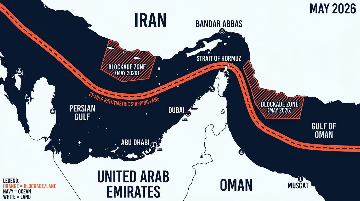
The catalyst that finally activated this geographic trap was swift and unprecedented in its kinetic scale. Following the initial military strikes on February 28, the waterway was effectively sealed by Iranian forces on March 2, 2026. The Iranian Revolutionary Guard Corps (IRGC) leveraged the spatial constraints of the channel, deploying rapid-attack speedboat formations, asymmetric drone swarms, coastal defense cruise missile batteries, and critical sea-mining operations. The deterrence effect was immediate and catastrophic for commercial logistics. Maritime transit plummeted, registering a massive 70% collapse in tanker traffic within weeks, resulting in an armada of over 150 massive commercial ships dropping anchor outside the Strait, paralyzed by war-risk insurance premiums and physical danger.
The friction compounded drastically on April 13, 2026, when the United States implemented a formal, hard-power naval blockade targeting vessels entering and leaving Iranian ports. Executed by the United States Armed Forces, including direct interdictions by the 31st Marine Expeditionary Unit and the guided-missile destroyer USS Spruance—which notably seized the Iranian-flagged vessel Touska on April 19—the operation effectively locked the Persian Gulf into a dual-layered militarized zone. The economic hemorrhage was staggering, directly costing the blockaded state an estimated $500 million daily in lost energy revenues. Yet, the true collateral damage of this cartographic seizure was exported thousands of miles eastward.
The 2026 Hormuz blockade proved a fundamental, unforgiving axiom of spatial economics: raw financial power is entirely subservient to geographic realities. A nation cannot consume what it cannot physically transport.
When mapping the geopolitical victims of the 2026 chokepoint closure, the data points overwhelmingly toward the Indo-Pacific. The Persian Gulf, for all its hydrocarbon wealth, is geographically an enclosed sea—a maritime cul-de-sac. The nations situated at the terminal end of this broken supply chain found themselves facing immediate, structural energy deficits. By the first quarter of 2026, empirical vessel-tracking data revealed that an overwhelming 89.2% of the crude oil and condensate flowing through the Strait of Hormuz was destined for Asian markets. The People’s Republic of China stood exposed at the apex of this vulnerability, single-handedly absorbing 37.7% of the total export volume.
This massive dependency locked Beijing, New Delhi, Tokyo, and Seoul into a geographic trap. Their industrial engines were tethered to a maritime umbilical cord governed by a waterway they did not physically control, located in a theater heavily contested by external hegemonic navies. From the historical perspective of 2031, the realization of this acute spatial vulnerability in May 2026 served as the supreme catalyst for Asia’s aggressive, multi-trillion-dollar pivot toward continental, overland supply chains. The immediate shockwaves of the blockade forced a permanent structural realignment, accelerating the construction of massive terrestrial pipeline networks bridging the Russian Far East and Central Asian republics directly into the Chinese mainland, intentionally bypassing the oceans entirely.

While consumer nations scrambled to redraw their import cartography, the hydrocarbon producers physically trapped inside the Persian Gulf were forced to rapidly deploy sovereign infrastructure to bypass the sea. As the waterway transformed from a bustling trade corridor into an active conflict zone, the physical geography of the Arabian Peninsula offered exactly two terrestrial lifelines. The United Arab Emirates and the Kingdom of Saudi Arabia were the only Gulf producing nations possessing the vast landmass and pre-existing pipeline architecture required to circumvent the militarized chokepoint. In the clinical lens of geography, their strategic response was to physically move their coastlines.
