

The Eurasian Fracture and the Middle Corridor’s Revenge
Why a narrow strip of inland seas and rugged mountains is becoming the most critical trade artery of 2026.


The cartography of global trade is undergoing a violent structural contraction. As we map the multimodal transit vectors of Q2 2026, the traditional east-west logistical arteries that have subsidized globalized commerce for three decades are essentially paralyzed. The Northern Corridor, stretching across the vast, uninterrupted plains of the Russian Federation, remains a geopolitical dead zone, blockaded by persistent sanctions and border militarization. Simultaneously, the Southern Route—the historically dominant maritime vector via the Red Sea and the Suez Canal—is crippled by an endemic cycle of asymmetrical warfare and maritime insurance premiums that have shattered the economic viability of the route. This spatial squeeze means the geography of supply chains must find a new path of least resistance.
When the peripheral oceans become too volatile, and the northern continental plains too politically toxic, global trade is violently compressed into the deepest interior of the Eurasian landmass.
This compression has forced the activation of a route once dismissed as too geographically complex: the Trans-Caspian International Transport Route (TITR), known as the Middle Corridor. In 2026, it is no longer a theoretical backup; it is the primary geographic necessity for moving goods between the manufacturing hubs of Western China and the consumer markets of the European Union. However, charting this corridor reveals a brutal topographical reality. Unlike the frictionless oceanic routes or the flat northern steppes, the Middle Corridor is a high-friction environment. It must cross the towering Tian Shan mountains, traverse the arid expanse of the Kazakh desert, navigate a landlocked body of water, and pierce the rugged topography of the South Caucasus.
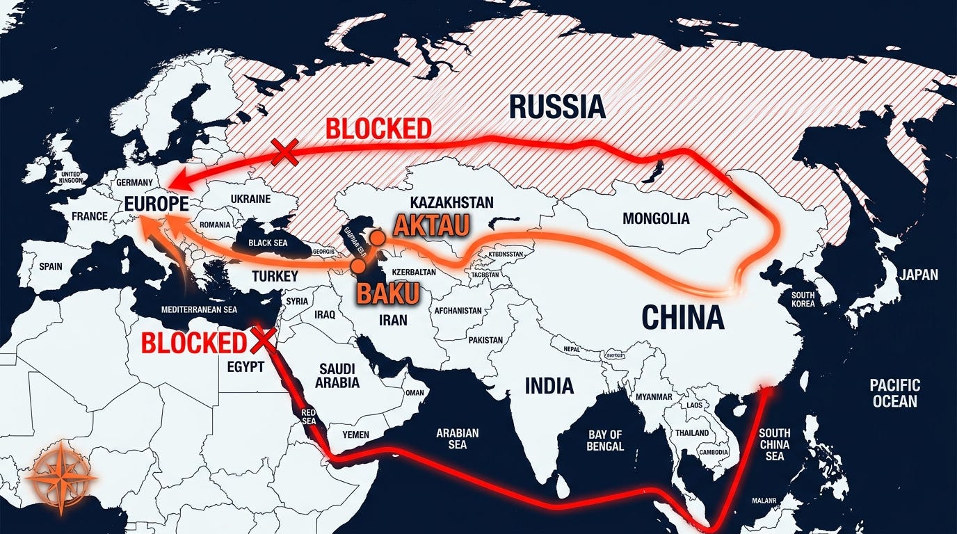
To understand the sudden expansion of this route, we must focus on its primary geographic bottleneck: the Caspian Sea. Historically functioning as a natural barrier to land empires, the Caspian is currently the spatial fulcrum of the entire Middle Corridor. It is a mandatory maritime bridge linking the steppes of Central Asia to the edge of Eastern Europe. By May 2026, unprecedented capital has been poured into the eastern shores of the Caspian, specifically targeting the Kazakh ports of Aktau and Kuryk. These are the staging grounds where the terrestrial momentum of Chinese rail freight meets the hydrographic reality of an inland sea.
The spatial challenge here is multimodal friction. Cargo arriving from the overland rail network must be physically lifted, transferred onto Roll-on/Roll-off (Ro-Ro) ferries or specialized container ships, transported 250 nautical miles across the Caspian water column, and offloaded at the Port of Alyat near Baku, Azerbaijan. Every transfer point introduces temporal decay. In response, 2026 has seen the aggressive deployment of a unified digital customs perimeter across the Caspian basin, effectively turning two distinct national port infrastructures into a single, synchronized transit mechanism.
The geoeconomic reality of 2026 is uncompromising: the state that commands the maritime logistics and ferry capacities across the Caspian Sea dictates the temporal pulse of all Eurasian east-west trade.

Once freight successfully bridges the Caspian basin, it enters the true terrestrial chokepoint of the Middle Corridor: the South Caucasus Funnel. From a cartographic perspective, this region is a logistical nightmare. Sandwiched between the imposing, snow-capped peaks of the Greater Caucasus to the north and the heavily militarized highlands of the Lesser Caucasus to the south, the Kura River valley forms a narrow, natural geographic corridor slicing through Azerbaijan and Georgia toward the Black Sea.
