

The Eastern Realignment
How global chokepoints and structural shocks are permanently redrawing the American maritime map.


The North American Eastern Seaboard is not merely a coastline; it is a highly sensitive geopolitical membrane. Stretching from the rocky deep-water inlets of Nova Scotia down to the shallow, muddy estuaries of Florida, this unbroken logistical chain acts as the primary circulatory system for the world’s largest consumer economy. For decades, the spatial distribution of cargo along this coast remained largely static, dominated by the gravitational pull of the New York/New Jersey megalopolis and the established mid-Atlantic nodes. However, as we observe the logistical data emerging in the second quarter of 2026, a radical spatial reshuffling is underway. The geography of American trade has fractured and reformed.
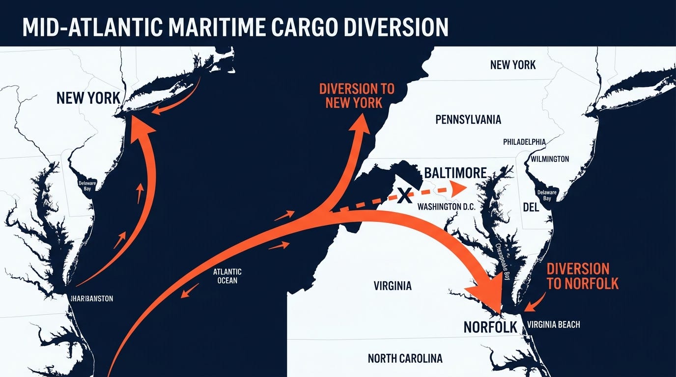
To understand this realignment, we must first look at the spatial anatomy of the mid-Atlantic coast. Geography dictates destiny, but infrastructure dictates capacity. The catastrophic loss of the Francis Scott Key Bridge in Baltimore in the spring of 2024 served as a violent geographical stress test. Overnight, the Patapsco River—a critical maritime artery handling the nation’s largest volume of roll-on/roll-off (RoRo) automotive cargo—was severed. The immediate aftermath proved that vulnerability in a single maritime node forces an entire continental logistics network to instantly remap its center of gravity.
The diversion of cargo away from Baltimore did not result in an even dispersal. Instead, it followed the path of least geographical and infrastructural friction. Cargo surged north to the Port of New York and New Jersey, and south to the Port of Virginia in Norfolk. Norfolk, possessing some of the deepest and widest shipping channels on the East Coast, absorbed the shock with clinical efficiency. By leveraging its direct double-stack rail corridors into the Midwest, Norfolk effectively bypassed the congested I-95 highway corridor, proving that hinterland connectivity is just as vital as ocean access.
This localized shock in the mid-Atlantic coincided with a far more profound global spatial crisis. Throughout 2024 and 2025, the two most critical artificial chokepoints in global maritime trade—the Panama Canal and the Suez Canal—simultaneously failed to provide reliable transit. The Panama Canal, suffering from historic, climate-induced freshwater droughts in Gatun Lake, severely restricted daily transits and draft limits. Meanwhile, the geopolitical inferno in the Red Sea and the Bab el-Mandeb Strait effectively closed the Suez routing for Western-linked tonnage, forcing vessels to circumnavigate the Cape of Good Hope.
These dual chokepoint crises completely scrambled the math of global shipping. For manufacturing hubs in Southeast Asia and the Indian Subcontinent attempting to reach the US East Coast, the Cape of Good Hope routing became the default survival mechanism. When global maritime arteries constrict, the ocean transforms from a frictionless highway into a landscape of topographical barriers, forcing supply chains to endure thousands of miles of costly geopolitical detour. Vessels arriving from the southern Atlantic trajectory hit the East Coast at an entirely different angle of incidence, mathematically favoring the southeastern ports over the traditional northeastern behemoths.

We visualize this structural shift by looking at the Atlantic basin not as an empty space, but as a heavily trafficked geopolitical arena. The arrival of ultra-large container vessels (ULCVs) from South Africa’s Cape requires immense port infrastructure, vast turning basins, and colossal crane heights. As shipping lines sought to minimize their transit times on these extended voyages, they prioritized ports that could offer instantaneous discharge and rapid inland distribution.
